
by Sasha Alex Lessin, Ph.D. (Anthropology, U.C.L.A.)
From ANUNNAKI, FALSE GODS * by Sasha Alex Lessin, Ph.D. (Anthropology, UCLA) & Janet Kira Lessin (CEO, Aquarian Media)
Examples Anunnaki sites in this post include those on the following list. Scroll down to the name of the country whose sites and history you wish to see first (or read the site reports as they stand, in rough order of their establishment).
Iraq
Lebanon
Turkey
Zimbabwe
Egypt
Pakistan & India
Jerusalem
Malta
France
Britain
Ireland
China
Cambodia
South America
Mexico, Honduras, Guatemala
North America
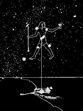
ETS FROM NIBIRU (The Anunnaki) MOVED AND FITTED HEAVIER STONES ON EARTH THAN WE CAN YET
Our science still can’t cut, move and fit huge rocks as well as the the 12-foot tall Homo Sapien ETs who came to Earth for gold 400,000 years ago from the planet Nibiru. The Nibirans cut stones as large as 10 tons with huge cutting tools run on power pulled from the earth.

The Anunnaki, other extraterrestrials and then the ancestors of humanity on every continent built megalithic–big rock–sites on Earth’s ley lines–oscillating telepathic internet fields where all who worship fuse their consciousness into one group mind and can communicate with people and their knowledge at other megalithic sites.

“Giant telluric [mind-harmonizing telepathic] waves, undulating vertically and linked to the geomagnetic field of Earth, create a network of crisscrossing lines all around the planet.” A team of Anunnaki builders, after Noah’s flood of 9703 BCE The builders marked crossing points with standing stones. Elongated shapes–mehir, steeples or towers) acted as antennae, attracted “cosmo telluric waves” that continue to flow through the worldwide network.
“These cosmo-telluric lines” let the Anunnaki, other ETs on Earth and our ancestors “gather a whole body of knowledge.” Hardy contends we can, at these sites, “trigger a shift to a heightened and more spiritual state of consciousness.” Though the ETs chose the sites, our ancestors in every era and on every land anchored them with stones and buildings. Once fixed, our forefathers’ reinforced the broadcasting power when they prayed at the sites. Our genitors experienced “planetary consciousness when they did rituals at the big-stone sites.” [Sacred Network: 4 – 8]
ANUNNAKI MOVED GIANT ROCKS WITH INVERSE PIEZOELECTRICITY & CEMENTED STONE INTO MOLECULAR CONCRETE TO MAKE MEGALITHIC STRUCTURES
Inverse Piezoelectricity–The Hutchenson Effect
After the Anunnaki and other ET builders employed tools with drilling and cutting capacities beyond any we yet possess (unless our clandestine military has such tools) they pushed the stones into place from their craft or by a 3-foot long sonar device shaped like a ice-cream cone. They took stones from the size airplanes to the size automobiles to make landing platforms, metallurgy facilities, power-generating pyramids, observatories, palaces, statues, roads, walls, cities and, in the south of Africa, millions of miles of electronic conveyance lanes.
The builders choose granite rocks with lots of quartz crystal and iron sensitive to electricity. After they extracted the rocks, the builders ran electricity into them which the iron conveys and which “makes the granite-crystal, briefly weightless.” The blocks are then moved effortlessly through the air, perhaps with high tech pusher beams of energy from aircraft. “Gigantic blocks of granite could be moved with little effort, no matter how much they weigh when not having pa powerful electric charge put on them.” For Ollantaytambu in Peru, the pusher-beams made giant rectangular-shaped cut-granite blocks jump from the quarry to slides above rivers between the quarry and the destination. The beams pushed the stones over the edge, where the builders made them jump across the river and up the other side of its canyon to building sites, where the builders carefully put the rocks in place in structures. They poured liquid metal down drill holes and stapled the rocks together with metal staples. [Childress, 2013: 303 -304, Temples: 79]
Some of the stones of 100 and more tons at Earth’s sites dating back tens of thousands of years feature stones quarried miles away from the sites. The quarries exhibit hollows where the stones were cut from the earth, and finished but abandoned stones as well.
Preah, the half-Anunnaki who created the megalithic launch pad at Angkor Wat, Cambodia, used a power tool and weapon of mass destruction our ancestors called a “sword.” His sword “thin as a feather, not of metal, but of light “more blinding than the sun.” With his “sword” he cut stone. With it, he could cut a ceramic jug so finely down the middle that the water only ran out when the two halves fell apart. Our ancestors called Preah’s laser or a plasma beam tool a “sword.” A plasma beam bunches charged particles that glow as they cut through everything as they respond to targeted magnetic fields. Ancient Chinese called the beam a yin-yang mirror. [“Aliens and Deadly Weapons”, in Ancient Aliens Episode Scripts, Season 3]
Molecular Concrete
Preah and later kings reduced local sandstone to a slushy concrete. They poured the sandstone concrete into molds that formed continuous mile-long walls on four sides of the temple complex. The walls nestle within a canal that surrounds the temple. Preah poured “magical water onto stone, which made the stone into a concrete which hardened in place as blocks in the structures of Angkor. We of this century also have a substance that can liquify stone: Brown’s gas. If we melt rock with one of our technologies, Preah surely did with Anunnaki technology, long before Brown.
Brown’s gas melts rock, ceramic and brick into stuff that looks like fused glass, way harder than the original rock.
Brown’s Gas mixes di-atomic and mono-atomic hydrogen and oxygen in an electrolyzer that splits water into its elements of hydrogen and oxygen in their mono-atomic state, H hydrogen and O oxygen. 442.4 Kcal added per mole H and O keeps them monoatomic. [http://www.eagle-research.com/browngas/fabuses/other.php].
The archway that leads, as you’ll read, to Pumapunka from Tiahuanacu on Lake Titicaca, Bolivia, “was patched up with a super concrete that had the original stone as one of its components and could therefore make a molecular bond instead of a chemical one like modern cement does.“ [Childress 2012: 85]
IRAQ
SIPPAR
SIPPAR: PREDILUVIAN SPACEPORT
The Anunnaki Goldmining Expedition built its first spaceport on Earth 400,000 years ago at Sippar (Eagle City, Tell Abu Habbah) on Iraq’s Euphrates river’s east bank, 30 km southwest of Baghdad.
THE LANDING CORRIDOR LAYOUT SHOWED ROCKET ROUTE
They built bases in Iraq “to outline the landing path to Sippar. Bad-Tibara (the Metallurgy Center), Shuruppak (Ninmah’s Medical & Science Center) and Nippur (Commander Enlil’s Command Center) lay on a line at a 45-degree angle to the twin peaks of Mt. Ararat meridian–the apex of a triangular landing corridor. That line crossed the meridian at Sippar.” They built other settlements to mark the flight line to Sippar. 
The Expedition constructed Nippur, their first Mission Control Center in the middle of the Landing Path. Noah’s Deluge buried Sippar; here’s what we found of it:


After Noah’s Flood buried, they built a second Mission Control Center in Jerusalem. (After the flood the Anunnaki later built Giza’s Great Pyramids, where they incorporated the Iraq triangle into the larger triangle for post-diluvial landing system in the Sinai).
In Iraq before the Flood, shuttles glided to Sippar with the Euphrates and mountainous plateau on one side, Tigris and the Zagros range on the other side. The craft neared Sippar at 45 degrees to the Ararat meridian safely between two hazardous areas. From the south, planes and vimanas (the detached command capsules from the larger spacecraft) crossed over the Persian Gulf. Coming and going a craft had an unobstructed field of vision and communication with Misuilt Lagash for Ninurta. In the 7th Century BCE (Neo-Babylonian Period)King Nabopolassar rebuilt the temple of Shamash at Sippar and dug a canal linking the city to the Euphrates.
Babylon’s King Nabuaid rebuild Utu-Shamash’s temple at Sippar. Utu made Sippar the seat of Sumer’s supreme court [12th Planet: 116, 300-304; Handbook: 130].sion Control at Nippur.
ZIGGURAT FUNCTIONS
The building at the Sippar Rocket Base, and ziggurats–the stepped platform pyramids with communication antennas–featured in the Anunnaki bases pointed the corners due north, south, east and west so their sides ran at 45 degrees to the four directions so “a space shuttle landing could follow certain sides of the ziggurat exactly along the flight path.” Each step in the stepped ziggurat “acted as a stage of an astronomical observatory with a predetermined elevation relative to the arc of the sky.” Anunnaki personnel lived on, stowed their weapons and parked their aircraft within or atop the ziggurats [12th Planet: 310].
SUMER, BUILT AFTER NOAH’S FLOOD, DUPLICATED PREDILUVIAN LAYOUT
The Anunnaki replaced bases after the Deluge of 11,000 BCE buried them. Mesopotamian kings (descendants of Noah’s sons Ham, Japhet, and Shem) duplicated the original building plans of each and rebuilt the bases in the same place as Anunnaki first built them–the same loci along the Landing Corridor.
In the 3rd Millenium BCE, King Gudea rebuilt Lagash for Ninurta. In the 7th Century BCE (Neo-Babylonian Period)King Nabopolassar rebuilt the temple of Shamash at Sippar and dug a canal linking the city to the Euphrates.
Babylon’s King Nabuaid rebuild Utu-Shamash’s temple at Sippar. Utu made Sippar the seat of Sumer’s supreme court [12th Planet: 116, 300-304; Handbook: 130].
LAGASH

Yahweh-Enlil’s son, champion, and enforcer Ninurta (AKA Ningirsu), long before we Earthlings had been created, defeated Anzu and the first Igigi (Nephilim) invasion from Mars. Ninurta ran Iraq for Enlil’s clan. Millennia later Ninurta organized the Earthlings and with them drained the floodwater and dredged the mud that covered Iraq in the Deluge of 11,000 BCE. Ninurta dug out paths for the Tigris and Euphrates Rivers; he built canals and irrigation ditches for what would become Sumer for the Hybrids with which the Anunnaki peopled Iraq/Sumer. So Sumer’s Earthlings, as well as the Anunnaki, regarded Ninurta as a hero. Yahweh decided to enhance Ninurta’s status to rival that of Enki’s son Marduk, who ruled Egypt.
LAGASH KING GUDEA INSTRUCTED ON TEMPLE FOR NINURTA
Around 2100 BCE, Yahweh rewarded Ninurta with a temple at Lagash (northwest of the confluence of the Euphrates and Tigris rivers and east of Ash Shatrah, Iraq). Yahweh told Ninurta to make Lagash a cult-center city of Earthlings. Someone–probably an agent of Ninurta–surreptitiously put a lapis Lazuli stone tablet with the plan of the temple next to the bed of Gudea, Lagash’s King.

Gudea consulted the oracle Nanshe, who interpreted his dreams. She said he should call the new temple “E.NINNU– the House of Fifty–to signify his claim to Enlil’s rank of fifty (the only number below Nibiru King Anu’s number. Anu’s rank was sixty.” Nanshe told Gudea he must work incessantly at the tasks a woman in his dream (Enki’s daughter Nisaba), would tell him “the size and shape of the clay bricks. Nanshe told Gudea that Ningishzidda (Thoth) would design the temple, step-by-step.
Ninurta married his aunt, Princess Bau (a daughter of Nibiran King Anu and Queen Antu) and dwelt with her in Lagash’s temple. Bau ran a health clinic for Lagash’s Earthlings.

Enlil supported Ninurta, told him to go ahead and make a temple, landing platform, observatory-planetarium, oracle room and armory at Lagash. The planetarium would show Earth’s highest “god” in the zodiacal circle of twelve planetary groups would rotate.
The honor and power of the god whose star group appeared in the skies over Iraq at sunrise on the first day of the Anunnaki New Year would rule as long as his or her constellation lingered over Lagash. This gave Enlil’s stretched-out Taurus constellation more years overhead at the New Years’ dawn greater duration in the Iraqui sky than the compact constellation that Marduk, Ninurta’s rival, had with his constellation, the Ram.
The struggle for supremacy [over Earth, and ultimately over Nibiru] pitted Ninurta against Enki’s firstborn Marduk so “Ninurta obtained the permission of his father Enlil to build a new temple that would express the rights of Ninurta to the Supremacy.” Ninurta said the new temple “would emulate the Great Pyramid of Giza” that Marduk and the Enkiites had in Egypt. The new temple of Lagash would “include enclosures for the Divine Black Bird [fighter-bomber plane] and the Supreme Weapon [a multi-headed missile launcher], an oracle chamber, and a place for the assembly of the gods.” [Divine Encounters: 195-193]
Lagash
LEBANON
BAALBEK
BAALBEK, LEBANON, THE LANDING PLATFORM SINCE 400,000 YEARS AGO 


Remains of the Nibiran Landing Platform at Baalbek Lebanon some 400,000 years ago as well as quarry miles away, ready to transport to the Platform  At Baalbek, Nibirans built a launch tower (shown on coin at left) for the goldmining expedition, “on a vast horizontal platform, artificially created 4,000 feet above sea level, surrounded by a wall.
The enclosed squarish area, 2,500 feet long, over five million square feet, was built before the Flood” [13,000 years ago].
Baalbek’s stones were “held together without mortar, rising stage after stage, to incredible heights from a vast stone platform. The massive stones formed an enclosure that surrounded a cavity, a hollow within which stood the rocket about to be launched. The encompassing walls were multileveled, rising in stages to enable servicing the rocketship, its payload, [&] a command module.
Coin, Baalbek
Baalbek included “stone blocks of incredible size, precisely cut and placed, including three colossal stone blocks that are the largest in the world, the Trilthon. The stone blocks that make up the Trilithon weigh more than 1,100 tons each and are placed upon older immense stone blocks, over sixty feet long with sides of fourteen to twelve feet, cut to have a slanting face that weigh 500 tons each.
There is even now no man-made machine, no crane, vehicle or mechanism that can lift such a weight of 1,000 to 1,200 tons–to say nothing of carrying such an immense object over valley and mountainside and placing each slab in its precise position, many feet above the ground. There are no traces of any roadway, causeway, ramp or other earthworks that could suggest hauling these megaliths from their quarry, several miles away.”
Nibirans “not only lifted and placed such colossal stone blocks but also carried them from a quarry several miles away. The quarry has been located and in it one of those colossal stone blocks had not been completed, still lies partly attached to the native rock; its size exceeds the Trilithon blocks.


Baalbek as Landing Platform
“Baalbek was incorporated into the post-Deluvian Landing Corridor of the Anunnaki when they planned the planning of a spaceport in the Sinai to replace the one in Mesopotamia wiped out by the Deluge. They ran a line from the peaks of Ararat through Baalbek and extended it to Giza, where they built the pyramids.
They placed the Great Pyramid and the anchor in Sinai that in the end delineated the Landing Corridor equidistant from Baalbek.”
“The stone blocks that comprise the platform are “so tightly put together that no has been able to penetrate it and study the chambers, tunnels, caverns and substructures hidden beneath,” though Arabs did penetrate a “460-feet long tunnel at the southeast corner of the platform.” They proceeded through “a long vaulted passage like a railway tunnel under the great in total darkness broken by green lights from puzzling ‘laced windows.” Nibirans “not only lifted and placed such colossal stone blocks but also carried them from a quarry several miles away. The quarry has been located and in it one of those colossal stone blocks had not been completed, still lies partly attached to the native rock; its size exceeds the Trilithon blocks. [Stairway: 168 – 176; Expeditions: 166 -179]
TURKEY
GOBEKLI TEPE

Gobekli Tepe, Turkey, an ancient (9000 BCE) amphitheater, focuses above on the star Deneb in the constellation The Swan or The Vulture. Gobekli sits on a ridge above the Plain of Harran–turf of Moon God Nannar (aka Sin-El-Allah after Noah’s flood).
Ampitheaters like Gobekli abound in this part of Anatolia. The builders made them ovoid-shaped with stone and mortar benches that face two central monolith-pillars. At Gobekli, the amphitheater surrounds the central monoliths stand 18-feet high. They weigh 15 -20 tons apiece and face each other across a space where a priest communed with the gods.
A century after the builders made a theater, it no longer (due to precession of the equinoxes) aligned with Deneb. So they buried the theater and, along the same ridge, build a new one atop or near the old, out of date one. They built ever-smaller theaters each century, as the Earth moved off its alignment with Daneb.
Central pillars in the middle of these theaters feature anthropomorphic statues. The statues’ arms wrap around them like those on Rapa Nui statues that the Anunnaki and the Capensis ETs erected with flood survivors. The builders of both Gobekli and Rapa Nui carved snakes on the statues.
Swidarians, Collins says, flood survivors from the North Mountains–Poland, the Carpathian Mountains and Belarus–came down to Turkey and got local hunters and gatherers to work for them and build these structures. Swindarians were tall hybrids with Capensis as well as Neanderthals; some of the Swindarinans had ELONGATED HEADS and left traces of their DNA in human populations.
Collins considers Deneb, the brightest star in The Swan and the star to which the ampitheaters orient, the home in the stars to which the old megalithic structures in Turkey, Ireland, UK and the Baltics point. Deneb points to “the exact point where the Milky Way splits into two to form The Great Rift–the Signus Rift.”
CAPPADOCIA

Marduk (AKA Satan, Ra, and in Turkey, known as AHURA MAZDA), ordered the Persian King Yima to build underground cities capable of blocking invaders and radioactive fallout.


A 20,000-person subterranean city at Cappadonia’s Derinku goes down eleven stories–280 feet down in all, spread out over a four square mile area underground. Fifteen-thousand small shafts air the city. Each story holds homes, temples, tombs, shops, oil presses and livestock pens. Tunnels connect Derinku with underground wells and other underground cities.
Each story-level in Derinkuyu had massive stone security gates.  The huge gates sheltered their floors from invaders or radioactive storms, like the storm Yahweh-Enlil unwittingly loosed over Iraq and Turkey in 2025 BCE, when he nuked Sinai and Canaan.
ZIMBABWE
At Enki’s palace–Great Zimbawe–we see a 12-fathom high tower and the lab he shared with Ninmah and Ningishzidda.


There, above the gold mines of the inland plains between the Limpopo and Zambezi rivers, the genetics team first adapted their Nibiran genome to Earth to create Ti-Amat, the first adapted homo sapiens woman and Adamu, the first homo sapiens man.


This ellipse-shaped complex lies within a mortarless stone wall 12 fathoms high and six meters thick.

The bricks, made from a mixture of granitic sand and clay. Great Zimbawe’s 11 meter-high outer wall extends 250 meters.
Enki’s palace sits among thousands of miles of twelve-foot wide lanes, lined with graniteboulders. Enki engineered sonar systems to transport water, gold diggings and machines over these lanes.

.
.
EGYPT
GIZA
 Sphinx Pyramids People
Ningishzidda designed the 5,955,000 ton Great Pyramid at Giza with eight concave faces. With sonar technology and the help of monoatomic gold to lighten the stone blocks, Ningishzidda and his assistants stacked 2,300,000 stone blocks–250 tons worth–on the pyramid. The pyramid’s outer mantle featured 144,000 polished and flat casing stones 100 inches thick and 15 tons each. The pyramid “covered 592,000 feet in area.”
“Granite used in the Great Pyramid gives off a significant electromagnetic charge, contains 25% quartz and has the ability to enhance sound. The magnitite in the granite is a natural magnet that creates around it a magnetic field. The Giza pyramids’ core consists of red granite, one of the most conductive rocks on earth due to its high contents of quartz, iron, and magnitite. It exudes natural radioactivity. This core is encased in a rough limestone with a high content of magnesium that acts as an electrical conductor. The limestone was dressed on the outside by Tura limestone–finer grained and highly polished–and because it contains minute traces of magnesium, unlike the inner limestone, it serves as an insulator, keeping the energy inside the temple. This energy seeks to escape to the top of the structure, so the tips of the pyramids were capped with a stone of dororite and covered with electrum, a two-thirds mix of gold and silver, making it an excellent conductor.” [Silva, 2012b: 203, 204]

The east/west parallel that crosses the most land and the north/south meridian that crosses the most land intersect here.
The Great Pyramid aligned with Alpha Draconis, the Pole Star at the time. The pyramid aligns also with the center of the land mass of the earth. The east/west parallel that crosses the most land and the north/south meridian that crosses the most land intersect here. “The Great Pyramid divides the oceans and the continents into two equal parts.” It “is a giant sundial. The shadows thrown from mid October to early March indicate the seasons and the length of the year. The length of the stone slabs that surround the Great Pyramid correspond perfectly to the length of the shadow on one day.” [Von Daniken: 236]
Casing stones of polished limestone covered the outside and reflected the sunlight people could, without magnification, see from Israel and from the moon.

The Great Pyramid, when built, aligned with Alpha Draconis, the Pole Star at the time.


Pyramidal chambers also, from their various views, shows lines of sight to Deneb (in the Swan) and Sirus, near the belt of the constellation Orion.
The Great Pyramid entrance had a 20-ton nearly invisible swivel door, nearly invisible when closed and lacked a grasp from the outside. The pyramid’s cornerstones have ball and socket construction that adjusts to heat expansion and earthquakes. Temperature inside stayed 68 Degrees Fahrenheit.
The relationship between Pi (p) and Phi (F) is expressed in the fundamental proportions of the Great Pyramid. [Ancient, 2014]
PAKISTAN
INDUS VALLEY

From 3300 to 1900 BCE, 1000 cities in the Indus Valley extended over an area twice size of France. The people of this civilization kept had cattle, sheep and goats. Each village had a crafts area, markets, jewlers’stalls. Inanna’s Indus Valley cities–Harappa, Mohenjo Daro and Dholavira and their agricultural village hinterlands–stretched over a million square kilometers 3000 kilometer along the Indus River. In Mohenjo Daro, 40,000 people concentrated in one square kilometer.
Indus Valley Civilization lacked caches of weapons and had instead a multitude of toys, musical instruments, metal tools, scales, pottery, jewelry, cloth, wheeled carts, statuary and caches of grain for commerce.
Boats from Dholavira traded all the way to the Arabian Peninsula. Indus Valley civilization smelted and traded copper, bronze, lead and tin.

MOHENJO DARO

Roads that intersected at right angles connected residential blocks in Mohenjo Daro–a city of 40,000 in one square kilometer. Gutters and rubbish bins lined the roads. The main street kept nine meters width. Atop the highest hill, where residents retreated from periodic Indus flooding, Mohenjo featured a huge public bath. Mohenjo had eighty public toilets and a sewage system that serviced the entire city. In the residential area, every house had its own tile bathtub and its own well.


Mohenjo Daro
Along the Indus, Inanna’s people grew barley, wheat, melons, peas, sesame seeds, cotton, cattle, buffalo, sheep and goats.
HARAPPA
 Harappa
Harappa featured two-stories high, baked brick identical houses with flat roofs; each with windows that overlooked a courtyard. Outside walls lacked windows. Each home had its own private drinking well and its own private bathroom. Clay pipes ran from the bathrooms to sewers under the roads. The sewers drained into streams.
DHOLAVIRA

Sixteen meter high brick walls surrounded Dohlavira, a commercial city of 48 acres surrounded with a population of. 20,000. Dohlavira contained grain-storage bins and reservoirs with flood control dams. The largest reservoir was 7 meters deep,79 long.
The dams kept water around the city for grapes (they made raisins) barley, wheat, peas, cotton and sesame seed crops and flowed downhill from the highest reservoir to lower ones. Rainwater channeled down a city-wide collector reservoir. Dikes diverted an ancient river–the Ghaggar–to water the area between Indus and Ganges.

.
.
.
.
.
.
Indus Valley cities featured reservoirs and multi-storied fired-brick buildings laid out along a grid of wide brick-paved streets with run-off gutters.
JERUSALEM


.
SOLOMON’S TEMPLE
To ready the Jerusalem site for the Enlil’s temple, Israel’s King David, whom Enlil forbade to build the temple, readied its site for his successor, Solomon. David had thirty-three hundred foremen guide seventy thousand carriers and eighty thousand stonecutters in the hills as they took large blocks of quality stone for the Temple’s foundation.
Solomon built Enlil-Yahweh’s first permanent temple on huge stones in 957 BCE on huge stones–too heavy to move and fit in place without Anunnaki technology (so we know that’s how the stones were moved).


Temple of the Mount Foundation Stones, Jerusalem Several massive stones ‘under-pin’ the Temple mount. They are estimated to weigh around 500 tons each. They were found when excavations along the western ‘Wailing wall’ uncovered them. Masonry similar to this: Baalbek in Lebanon, and at Giza, Egypt.
The Temple’s east-west axis aligned with the equinox.
David gave Solomon a scale model and architectural drawings for the Temple.
Its east-west axis aligned with the equinox. David, gave Solomon a scale model and architectural drawings for the Temple.


Solomon set the temple so the sun at dawn entered the Tabernacle at spring and autumn equinoxes.
The temple featured a 100 x 200 foot main hall and a smaller room for Moses’ Ark. Solomon put the Ark on the rock where Abraham started to kill his son Isaac to prove himself loyal to Enlil. The new temple replaced the portable one Moses made in the desert, local sanctuaries and altars in the hills.
The Temple complex had a large basin (called the “Brazen Sea”) 10 cubits wide brim to brim, 5 cubits deep and with a circumference of 30 cubits around the brim on the backs of twelve oxen. The basin held 3,000 baths.
The Temple Palace, 40 cubits long, had walls lined with cedar, on carved with figures of cherubim, palm-trees and open flowers overlaid with gold. Fir-wood overlaid with gold covered the Temple floor. Olive-wood doorposts held doors, also of olive, boasted carved cherubim, palm-trees, and flowers, all being overlaid with gold.
Egypt’s Pharaoh Sheshonk I sacked the Temple a few decades later.
In 931, when Solomon,died, Abraham’s descendants split their turf into the kingdoms of Judea in the south, Israel on the north.
In 835 BCE Jehoash, King of Judah, renovated the Temple, but in 700. Assyrian King Sennacherib stripped it again. In 586, Nebuchadnezzer, Marduk’s Babylonian King, sacked Jerusalem and destroyed by the Temple.
In 539,Cyrus of Persia, whom Marduk welcomed, conquered Babylon and returned Nebuchadnezzar’s hostages to Jerusalem. Cyrus built the Second Temple from 538 to 515.

This second temple narrowly avoided being destroyed again in 332 BCE when the Jews refused recognize Macedonian King Alexander as a god. Ptolemies ruled Judea and the Temple from Egypt after Alexander died.
Seleucid King Antiochus III defeated Egypt in 198 BCE. He prompted a short-lived rebellion in 187 when he introduced Marduk-Zeus and the Greek pantheon into the temple. Antiochus IV Epiphanes again pushed the Greek gods for the Temple and, when the Jews again rebelled and Antiochus again crushed them, he again he forbade circumscision which marked Jews as followers of Enlil. Antiochus banned the Jewish Sabbath, put a statue of Zeus in their temple and had Greek priests sacrifice pigs there. When a Greek ordered Jewish priest Mattathias to perform a Hellenic sacrifice, Matathias killed him.
In 167 BCE the Jews rose up behind Mattathias and his five sons to fight and win their freedom from Seleucid authority. Mattathias’ son Judas Maccabeus re-dedicated the temple in 165 BCE and the Jews celebrate this event to this day as a major part of the festival of Hanukkah.
Judas Maccabaeus rededicated the Temple under Judas Maccabaeus in 164 BCE.
During the Roman era, Pompey entered (and desecrated) the Holy of Holies in 63 BCE, but left the Temple intact.
In 54 BCE, Crassus looted the Temple treasury Jews revolted again but Romans subdued them again in 43 BCE.
Herod the Great renovated the Temple in 20BCE; When Romans occupied Judea, they let Jewish priests run the Temple. Then in 70 CE, Romans destroyed the Temple.

During the last revolt of the Jews against the Romans in 132–135 CE, Simon bar Kokhba and Rabbi Akiva led another failed revolt from 132 to 135 and the Romans banned Jews from Jerusalem.
The Temple Palace, 40 cubits long, featured walls lined with cedar with carved cherubim, palm-trees and open flowers overlaid with gold. Fir-wood overlaid with gold covered the Temple floor. Olive-wood doorposts held doors, also of olive.
The Temple complex featured a large basin (called the “Brazen Sea” measured 10 cubits wide brim to brim, 5 cubits deep and with a circumference of 30 cubits around the brim, rested on the backs of twelve oxen It held 3,000 baths for the purification by immersion of the body of the priests.
MALTA (Part of Sicily when these structures were built.)

Malta Gozo preEgyptian
.

A temple both below a limestone hill and beneath it too, the Hypogeum near Malta’s capital Valletta, dates back to either before Noah’s flood of 11,000 BCE or from before Thera erupted and killed Minoan hegemony in the eastern Mediterranean. One large room in the Hypogeum, The Oracle Room, amplified sound a hundred times. People curled up in small rounded cubicles carved into the walls to listen. The part of the Hypogeum Malta lets us see holds 30 rooms that passages, stairs and halls link. The builders cemented the walls with concrete of compacted rock dust and water. In the rooms, they smoothed the walls with imported flint instruments. [Coppens, 2012]
Before authorities removed them, long-headed skeletons were among the many bones washed in from flood.
The structure also contained a statue of a grey (below). 
Malta youtubes below, following the acacemic convention of ignoring extraterrestrial influences, considered Malta’s builders to be non-technological, but Sitchin’s work clearly shows Anunnaki influence and worship of the Anunnaki Great Goddess Ninmah (Lilith). I include these tubes for their photos.
BOSNIA
BOSNIAN PYRAMIDS SHOW STONE MADE INTO CONCRETE, THEN BLOCKS

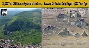

Cement for the Bosnian Pyramid
Semir Osmanagich describes pre-Deluge Bosnian Pyramids–the biggest 700 feet high, (vs Giza’s 450 feet). Nibirans probably build these structures and the labyrinth beneath them. The Anunnaki built the Bosnian Pyramids of huge blocks of very fine poured concrete. The Deluge buried the 5 pyramids about 13,000 years ago. Under the Bosnian Pyramid complex, Osmanagish found a labyrinth of tunnels with fresh running water. 
The tunnels lead to chambers that connect the five pyramids. The chambers held ceramic sculptures with runic writing on them. 


Under the Pyramid of the Sun little generators still run on Tesla technology.The pyramid still sends an ever -growing energy wave up and releases a high frequency sound wave (like that Tellinger reports from the South African structures and lanes). 
All who’ve worked inside these tunnels come out euphoric; the vibrations inside release endorphines and pleasurable sensations in them. The vibrations also purify the water that runs through the pyramid complex.
The Atlantean builders of these pyramids preceded the Anunnaki occupation of the Middle East and Africa by millenia. From 400,000 BCE on, the Anunnaki took Iraq, Sinai, and Africa. After 2025 BCE, Anunnaki hybrid Earthlings who fled the nuclear devastation Yahweh (Enlil) loosed upon them, merged with Atlantean Earthlings in Europe, Asia and elsewhere.
FRANCE
CARNAC

At Carnac, France, Anunnaki Silva calls the “Seven Shining Ones, Followers of Horus” set 4000 huge stones in thirteen parallel lines along 31 fault lines–the biggest quake fault lines in France, where the earth’s electromagnetic vibrations were greatest. The lines of highly magnetic quartz and magnetite start and end in egg-shaped rock circles “that amplify and release telluric energy throughout the day.” The alternating release and magnification creates electric induction.
Carnac’s menhirs–upright monoliths–are accumulators.

Man show his height, half that of one of Carnac’s accumulator- menhirs.
Carnac’s dolmans–two or more upright stone groups–are coils.

Dolmen
Carnac’s stone circles were both concentrators and accumulators. The “specially-choosen rocks, high in concentrations of quartz, transported from 60 miles away are piezoelectric; they generate electricity when subject to vibrations.” And France vibrated most at Carnac. [Silva, 2012: 95 -96]
BRITAIN
STONEHENGE

After Enki ordered Ningishzidda to cede Egypt to Marduk, Ningishzidda built a stone observatory at Stonehenge, a site he chose for it. Ningishzidda–architect of the Anunnaki–goldminers from the planet Nibiru who came to Earth 450,000 years ago–built, and with Middle Eastern and Black Olmec crew from Central America, rebuilt Stonehenge II and III from 2100 and 2000 BCE on the Salisbury Plain in Britain (80 miles from London), among people who had inhabited the area since 30,000 BCE.
 Ningishzidda/Thoth
“Stonehenge, built initially around 2900 BCE (Stonehenge, Phase I) is the most elaborate of nine hundred ancient stone, wooden and earthen circles in the British Isles, as well as the largest and most complicated one in Europe. Stonehenge, a planned astronomical observatory” adjusted for latitude, let its builders fortell eclipses, solstices, moon as well as changing apparent positions of stars.


Stonehenge features thirty upright stones, of which seventeen remain: “pairs of huge upright stone blocks, each about thirteen feet high, connected at the top by a massive lintel stone to form free-standing Trilithons erected in a semicircle, surrounded in turn by a massive circle of similar giant stones connected at the top by lintels carved to form a continuous ring around the paired uprights. Inside this massive stone ring, smaller stones (bluestones) from 250 miles away over land and two miles down the Avon River from southwestern Wales, of which 29 are still there, form the Bluestone Circle outside the Trilithons and a bluestone semicircle.” “Within this second ring stood five pairs of trilithons, making up the Sarsen Horseshoe of ten massive sarsen blocks. The innermost circle consisted of nineteen bluestones that form the Bluestone Horseshoe. Within this innermost compound, on the axis of the whole Stonehenge complex, stood the Altar Stone–a sixteen-foot long dressed block of blue-grey sandstone half-buried under an upright and the lintel of one of the Trilithons.
“The rings of stone are in turn centered within a large framing circle. It is a deep and wide ditch whose excavated soil was used to raise its banks and forms an encompassing ring around the whole Stonehenge complex, a ring with diameter three hundred feet. “A circle of fifty-six deep pits (Aubrey Holes) surround the inner bank of the ditch. “Two stones, on opposite sides of the ditch’s inner embankment and further down the line, two circular mounds with holes in them once held stones akin to the first two stones and the four called Station Stones, connected by lines outline a perfect rectangle.

The embankment had a wide gap that opened into the concentric rings of stones, holes and earthworks. The opening in the ditch, oriented northeast, leads to a causeway (the Avenue). Two parallel embankment ditches outline this avenue, leaving a passage thirty feet wide for a third of a mile where it branches northward toward the Cursus, an elongated earthwork at an angle to the Avenue; the other branch of the Avenue curves toward the Avon River.
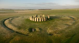
A line drawn through the center of the Avenue passes through the center of the circles and holes to form the structures axis” along which are marker stones, one of which, the Heel Stone, were placed along the axis.


Some of the bluestone semicircles are missing, some lie about as fallen giants.

Stonehenge began with a ditch and a berm, an earthen circle with a circumference of 1050 feet at its bottom, twelve feet wide, six feet deep, digging up two raised banks within this outer ring of the circle are 56 pits. Ningishzidda left the northeast part of the dirt ring undug as an entrance to the middle of the circle. The two (now missing) gateway stones that flanked the entrance. The entrance stones gave the Heel Stone, a massive boulder set four feet underground and sixteen feet above on a 24 degree angle round points on which to create lines of sight down the Avenue that movable pegs set into holes on the entrance stones. Ningishzidda put four rounded Station Stones within the circle to form a perfect triange. That was the extent of Stonehenge 1–the Earthen Ring, an entranceway axis, seven stones, and wooden pegs.
About 2100 BCE, Ninghzidda directed the Wessex people to add four-ton bluestones to Stonehenge; now called Stonehenge II. A double Bluestone Circle thus surrounded Stonehenge II. The builders shifted the Heel Stone, widened and realigned the Avenue to keep up with the changes in the Earth’s tilt made in the sunrise point. Ningishzidda and the Wessex moved the “Altar Stone” when the remodeling began.
Stonehenge III: Around 2000 BCE, Ningishzidda re-erected the Heel Stone and dug holes for new sightings. He completely dismantled the Bluestone Circle of Stonehenge II. With Anunnaki sonar technology, he brought 77 fifty-ton sarsen stones from Marlbough Downs, forty miles away. He incorporated nineteen of these bluestones in a new inner oval of stones topped by lintel stones and placed the others bluestones ready to be inserted in holes dug for two new circles (not yet completed). He replaced the old entrance stones with two huge new ones. [Time: 39 – 180]
IRELAND
NEWGRANGE (County Meath)
One of Ireland’s many Anunnaki observatories, Newgrange, a large circular mound of stone with a long hall and inner rooms. Anunnaki flood survivors built Newgrange and other stone observatories in Ireland to track the moon, sun, and the precession of the equinoxes in relation to the constellation Signa (aka the Swan or Southern Cross), where they could see Anunnaki craft and Nibiru nearingEarth.

Grass grows atop the layers of earth and stones that make the Newgrange mound. The mound measures 249 feet across and 39 feet high. Inside, a hallway of large stone slabs engraved with star maps stretches 60 feet to three small chambers off a larger central chamber with a high corbelled vault roof.

Each smaller chamber has a large flat basin stone. Once a year, at Winter Solstice, the rising sun shines directly along the long passage and lights up the inner chamber. For 17 minutes, sunlight enters the passage through anopening, known as a roofbox, directly above the main entrance.

Sunlight focuses on a triple spiral star map on the front wall of the chamber.

CHINA
PYRAMIDS
Pyramids flattened on top for aircraft landing abound in northern and central China’s (though China’s bosses hide this) rival Egypt’s and Central America’s for age–12,000years ago–and size.

Chinese emperors claimed descent from these “skymen-godpeople” who landed in “flying dragons” from another planet. The pyramids show astronomic alignment that dates them to the times the Anunnaki girded Earth with these structures. Records of that time speak of the emperors descending from heaven in flying dragons.

The tallest pyramid reported rises 300 metres high. Its sides measure 500 metres long –two times larger than and twenty times the volume of the Great Pyramid at Giza. The Chinese and Giza pyramids both align their baselines with north-south andwest-east. Stones once covered the Chineses pyramids but now only a few stones lie at the bottom; both have water channels from nearby rivers.
The Xianyang pyramid in Qinghai province near Mount Baigong’s top rises 200 feet amidst pieces of pressurized fuel and water pipes made of cobalt and elements exogenous to Earth.


China’s Xion Pyramids, like Egypt’s Giza Pyramids, replicate Orion in the sky.
DROPA STONES
In addition to the Anunnaki, Chinese relate ETs they call the “Dropa,” stranded from an exploration expedition crashed on Earth some 12,000 years ago in the Baian-Kara-Ula Mountains on the Chinese-Tibetan border.


They left stones the Chinese call “Dropa stones.”

The Dropa covered cavern walls with pictograms that show our Solar System and map routes among the stars with intersecting lines and dots. Their pictograms illustrate frail beings with round helmet-like bowls on their heads. In one of their caves a stone disc had a thin spiral groove filled with hieroglyphics. Another disc shows aliens with bulging heads and withered bodies. The disks had a hole in the middle and, when spun, emitted electrical impulses. [Coppins, 2010; Aym, 2011]
VIET NAM {Under contruction}
CAMBODIA
Angkor Wat’s huge city complex centers about a square (5,000 feet by 4,000 feet), walled, moated temple.* The temple sits atop an ancient Anunnaki landing platform, power station and metallugy plant. The temple complex features red sandstone paved causeways “lined with stone figures who pull a hooded serpent.” The moat is 623 feet wide, the walls on each side, a mile long. Within the walls, paved courtyards join three galleries. A large tower caps the highest, center gallery.

Before the world-wide Deluge of 11,000 B.C., Preah Pisnokar, a part-Earthling, part-Anunnaki, built a landing-platform, power station and gold-processing plant at Cambodia’s Angkor Wat. He built Angkor with advanced technology from Nibiru, the planet of his mother. Preah and later kings reduced local sandstone to a slushy concrete.
They poured the sandstone concrete into molds that formed continuous mile-long walls on four sides of the temple complex. The walls nestle within a canal that surrounds the temple.
Preah poured “magical water onto stone, which made the stone into a concrete which hardened in place as blocks in the structures of Angkor. He probably used technology Dunn proved in Egypt’s Giza Pyramids. Angkor generated power as part of a world-wide grid Anunnaki pyramidal power stations and monoliths that accessed and augmented power for aircraft, communication, lighting and computing.
Here’s how the Anunnaki, and probably Angkor’s builders, generated power. From the canal around Angor’s walls, they piped water into a stagnant pool under pyramids. They pressured the stagnant pools with pumping and/or sonar devices. This created a powerful vibration moving up the structures. In sealed chambers above the vibrations from the pools, they exploded hydrogen (from hydrochloric acid they mixed with hydrated zinc). [Dunn, C., in http://enkispeaks.com/2013/12/20/mars-and-earths-pyramid-parallel-power-stations-statues-spaceports/]
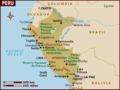
SOUTH AMERICA
13,000 years ago Earth’s climate deteriorated in the run-up to the perigee of 10,500 years ago that caused Noah’s flood. Enlil, Commander of the goldmining expedition from the planet Nibiru to Earth (the Anunnaki), ordered a second interplanetary spaceport atop the Andes, where his son Adad had built a landing platform around 15,000 BCE [Lost Realms: 222]. Enlil wanted the second rocket base in case Marduk and his ex-astronaut allies (the Igigi) overran the Sinai rocketport that Enlil’s grandson Utu ran.
Enlil, under orders from his father, King Anu, back on Nibiru, expected to return to Nibiru with the Nibirans he commanded as well as enough gold to powder into Nibiru’s atmosphere to protect it from destructive dissipation.
Enlil warned Anu that Marduk, the son of Enlil’s rival, Chief Scientist Enki, had created alliances not only with the ex-astronauts, but also with the hybrid Erectus-Nibiran Earthling miners and slaves Enki had made from the Nibiran genome. Marduk and his allies, Enlil and Anu realized, could push the claim of Marduk to rule Nibiru by dint of the treaty Anu had sworn with Marduk’s mother’s father, Alalu, Anu’s predecessor on the Nibiran throne.
PUMAPUNKU
Enlil sent his youngest son, Adad-Viracocha and Adad’s older half-brother General Ninurta to the Andes to scout out a potential second spaceport. They found their ideal site at Lake Titicaca, Earth’s highest (913,861 feet) lake–perfect for boats–20 by 44 miles large, 100 -1000 feet deep and dotted with over 41 islands.

Waters running from the lake gave the Anunnaki placer gold and cassiterite tin and bronze for their European and Middle Eastern centers. The Desaguadero river flows from the southwest corner of Lake Titicaca into the satellite lake, Lake Poopo, 260 miles to the south; “there is copper and silver all the way to the Pacific Coast, where Bolivia meets Chile.” [Lost Realms: 242 – 243]
A moat surrounded Pumapunku and connected to a canal system that ran to lake Titicaca, fifteen miles away through level ground. Upheavals, probably from the same disturbances that caused the destruction of the Nile area that Moses, whom Enlil-Yahweh forewarned, from the nearing of Nibiru or its lagrange points in 1450 BCE, destroyed the huge landing platform and scattered its H-shaped 400-ton twelve by ten by two foot thick red sandstone blocks that Viracocha (Adad-Ishkar) had quarried ten miles from Pumapunku.

“A destructive wave of water from Lake Titicaca violently destroyed Pumapunku, Tihuanacu to the south of the lake.” [Childress, 2012:107, 177]

“The stones at Pumapunku interlocked by grooves and articulated notches in the edges of the stones and cemented together by keystone cuts and bronze clamps.” [Childress, 2012: 105; Lost Realms: 211]

Adad’s workers survived Noah’s flood on Titicaca and Coati Islands in the sheltered southern portion of the lake.

Adad and his Sumerian foremen had them build, 1/4 of a mile from Pumapunku, Tiahuancu, aka “Tin City,” [Anuku = “metal granted by the Anunnaki.”] a two-square-mile city, metallurgical, temple, and observatory complex powered by electricity, on the shore and a with subterranean chambers. Tin supplies had run out in Europe after 2600 BCE, then Adad’s Cassites [Kosseans] Earthlings, related to the Hittites and Hurrians, flowed vast amounts of tin from South America to the Near East. [Lost Realms: 243 -245]
The Anunnaki employed “portable power plants” and “rotating magnetic fields” that gave Tiahuanacu AC power.” They “set up hydroelectric or wave stations to generate a large amount of power to send via microwaves to satellites and then redirect them to the remote parts of the earth as a form of usable power.” They sent cargos of precious metals and dried or honey-packed psychedelic mushrooms around the world. [Childress, 2012: 151]
The Anunnaki smelted, at high temperature, alloys including plantinum and extracted mercury from mineral cinnabar. They used the mercury to extract nearby silver. They built also an underwater city, Huanacu, some 80 feet down, hewn into the northern side of Titicaca Island. Tiahuanacu’s “builders planned Tiahuanacu in advance, with diverted rivers, water reservoirs on the top of pyramids (on or in which water washed ores) and massive stone [refining] structures with gigantic solid-stone doors. Pumapunku, the original New World El Dorado-Ophir city (the one to which Israel’s King Solomon flew over the Pacific from the Java Sea) featured gigantic walls covered in sheets of gold, golden masks, sun disks, gold-woven tapestries and drill holes to attach sheets of gold and other gold items.”
Nearby, Bolivians gathered the Fuante Magna Bowl, that bore ancient Sumerian cuneiform writing circa 3000 BCE and the Aymara language that the descendants of Ka-in developed from Proto-Elamite or Akkadian [Childress, 2012: 86, 109, 129 – 131, 146,150].

Tiahuanacu set off Pumapunku with a grand gate, the “Gate of the Sun,” originally a doorway for a solid granite door to for a nine-foot tall person or a person with an elaborate headdress.


The door led to a smashed 400 by 450 foot rectangular astronomical observatory called the “Kalasasaya,” that a moat had surrounded. The building, like a similar building at Pumapunku, had been destroyed and the door frame moved to form an arch leading to Pumapunku.
The Nibirans cut and shaped the gate as it stood in Tiahuanacu from a single hundred-ton, 10 x 20 foot stone block that features a carving of Viracocha-Adad, with golden tears. Tears, which represent the molton gold, tin, iron, platinum and mercury Tiahuanacu refined, run down his cheeks. The statue wears an elaborate headdress and holds Adad’s symbol, the forked lightening the zodiac of Sumerian Anunnaki. Reliefs of 30 “bird men”on Adad’s right–probably Nibiran astronauts–run toward him; one of these holds the trumpet-like object the Anunnaki used to move large stones.

After the building that contained the gate broke apart, the Anunnaki reconstructed it and incorporated as an arch to Pumapuku for a pilgrimage site for Andean “Indians.” Next to the gate stands a wall into which the builders sculpted heads of the various Earthling and ET types that visited the site [Childress, 2012: 88; Lost Realms: 210, 216 -217].

 Relief on Pumapunka wall (left) looks like contemporary Grey (Right).
Around 3800 BCE, Nibiru’s King Anu and Queen Antu flew with their grandson, Ninruta, from Sumer to the Tiahuanancu where a gold-plated enclosure (held together with solid gold nails) he and Adad had built awaited them. They saw the Spaceport on the 200 square-mile Pampa plain below where. On the runway, “Anu and Antu’s celestial chariot stood ready, with gold to the brim it was loaded.” Anu pardoned Marduk tor his last offensive against Enlil, then the King and his Queen rocketed off to Nibiru, then to Mars, then to Nibiru. Enlil ordered Adad to guard the Enlilite South American facilities from Marduk while he and the other Nibiran Earth Mission leaders returned to Sumer. [Enki: 272-276, Lost Realms: 255; Journeys: 206]
By 2200 BCE, as supplies of tin for bronze dwindled in Europe, Adad sent tin aplenty from Tiahuanaco back to Sumer, through his Hittite-Cassite subjects in Turkey. Descendants of these Middle Easterners still dwell on Titicaca and Coati Isles. Tiahuanaco, after most of the Anunnaki returned to Nibiru, became a pilgrimage site for the growing “Indian” population. There, Adad directed the construction of Mochica, Chan-Chan, Cuzco, Macho Picchu, Chavin, Ollantaytambu and tutored a couple he chose to create Machu Picho [Time: 247].
From Lake Titicaca and Tiahuanacu in Bolivia and Peru’s south, Anunnaki spread megalithic culture–landing platforms, metallurgical plants, pyramid power plants, astronomical observatories, palaces, canals, homes, statues, city walls, roads, bridges and quarries. Everywhere they settled, they left deep, extensive tunnels that moderns have not yet explored. Anunnaki culture spread North into ancient, pre-Inca Cusco, Ollantaytambu, Machu Pichu and Chavin. The Anunnaki mined copper and gathered gold and alluvial casseiterite–oxidized, water-washed tin from the Eastern coast of Lake Titicaca and the Lake Poopo area southeast of La Paz (down the Desaguardero River from Tiahuanacu).

Anunnaki brought successive waves of descendants of Ka-in, the South American Indians to coastal settlements along the Peruvian coast. At Paracas Bay, Adad blasted a huge image of his metal tool with its forked lightning to welcome incoming boats and aircraft from the Pacific.
OLLANTAYTAMBO


Ollantaytambo’s 637 km (miles along the Urubamba River from Tiahuancu (roads and airroute erased)
Ollantaytambo rests 637 km from Pumapunku, 45 miles north of Cuzsco. Ollantaytambo lies northwest along the Urubamba, on an exact 45 degree angle line between the Titicaca Island off Tiahuanacu and the Equator. “A 45-degree line originating at Tiahuanacu, combined with squares and circles embraced all the key ancient sites between Tiahuancu, Cuzco and Ollataytambu.” Earth’s tilt (obliquity) when the Anunnaki laid out this grid was 24 degrees, 08’ in 3172 BCE, the Age of Taurus [Enlil’s Age] between 4000 BCE and 2000 BCE.” [Lost Realms: 199 – 205]
Ollantaytambo, a landing platform (probably for the gold refinery at Sacashuaman, 60 miles to the southeast) rests “atop a steep mountain spur” and overlooks “an opening between the mountains that rise where the Urubamba-Vilcanota and Patcancha rivers meet.”

On the summit “megalithic structures begin with a retaining wall built of fashioned polygonal stones.

Through a gateway cut of a single stone block, one reaches a platform supported by a second retaining wall of polygonal stones of a larger size. On one side, an extension of this wall becomes an enclosure with twelve trapezoid openings–two as doorways and ten false windows. On the other side of the wall stands a massive gate to the main structures.” The Anunnaki channeled a stream through Ollantaytambo’s structures. Childress suggests Ollantaytambo featured a control building for an airport below the plaza along the river. [Lost Realms: : 315]


“A row of six colossal monoliths stand on the topmost terrace. The gigantic stone blocks are from eleven to fourteen feet high, six or more feet in width and vary in thickness from three to over six feet. These 50-ton or so blocks stand joined together without mortar with long dressed stones inserted between the colossal blocks to create an even thickness. The megaliths stand as a single wall oriented southeast. One of the monoliths touts a relief of the “Stairway symbol” of Tiahuanacu” that shows the connection between Earth and Sky.
Something interrupted Ollantaytambu’s construction; “stone blocks lie strewn about,” with T-cuts for poured metal clamps in them to hold the blocks together during earthquakes. The clamp-cuts duplicate those at Tiahuanacu. “A levitation device made the stones leap down the road from the quarry to slides, where the stones would be pushed over the edge and retrieved at the bottom. They would again be made to jump to the river and across, then up to the plaza. During this process, certain stones were “lazy” and could not be made to jump properly and were therefore abandoned.” [Childress, 2012: 303]

The Anunnaki carved huge blocks of very hard red [porphyry] granite that holds large-grained quartz crystal, from Kachiqhata, the opposite mountainside of Ollantaytambo’s valley. There builders hewed and shaped the blocks, then, with inverse piezoelectricity, moved them over two streams to slides on each side of the rivers, then up to Ollantaytambo where they raised, precisely placed and fused the blocks together. Though they brought many blocks across the river, the builders left 40 or more on the river’s eastern side. [Childress, 2012: 259 – 303; Lost Realms: 199 – 205]
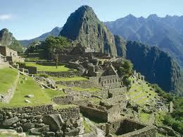
MACHU PICCHU (Tampu-Tocco)
On the eastern slope of the Andes, 7,585 feet above the sea, Machu covers 32,500 hectares4,000 feet above a bend in the Urubamba River, “which forms a horseshoe gorge half encircling the city’s perch, 75 miles northwest of Cuzco. Machu “was situated to control access to Ollantaytambu and Tiahuanacu.
 Machu Picchu “first served as a model for Cuzco, then emulated it.” Both Machu and Cuzco “consisted of twelve wards, royal-priestly groupings on the west and residential-functional ones occupied by the Virgins and clan hierarchies on the east separated by wide terraces. Common people tilled and cultivated the mountainsides. They lived outside the city and in the surrounding countryside.”
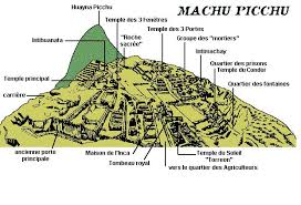
“Royal residences are built of ashlars [squared facing stones] laid in courses, finely cut and dressed.”
In the most ancient area, the Temple of Three Windows, Sacred Plaza [landing platform?] and Principal Temple display huge, precisely-cut stone blocks locked together without mortar.
“One of the stones has 32 angles. Cutting, shaping and angling of the hard granite stones was as though they were soft putty. White granite stones had to be brought from great distances, through rough terrain and rivers, down valleys and up mountains.
“The Temple of Three Windows has only three walls” and on its open, western side” faces a 7 foot tall pillar for “astronomical sighting purposes.

“The Principle Temple too has only three walls, some twelve feet tall. The western wall is constructed of just two giant stone blocks held together by a T-shaped stone.”

A huge monolith, fourteen by five by three feet, rests against the north wall of the Principal Temple.

The Intihuatana:

“Winding steps lead from the northern edge of the Sacred Plaza up a hill whose top was flattened to serve as a platform for the Intihuatana, a stone cut with precision to measure the movements of the sun, determine the solstices and make the sun return, lest it return the Earth to darkness that occurred before.”
The Torreon:

“At the end of the western part of Machu Picchu, the semicircular Torreon is built of ashlars “creates its own sacred enclosure at the center of which there is a rock that’s been cut and shaped and incised with grooves” like the rock in Jerusalem’s Temple Mound and Mecca’s black stone.
The Cave:


Beneath Machu, lies a huge cave “enlarged and shaped artificially to precise geometric forms, masonry of white granite ashlars. This is the cave from which the Anunnaki sent the first Inca king to found Cuzco, 75 miles southeast of Machu. [Childress, 2012:319 -343; Lost Realms 140 – 154]
CUZCO

Cuzco, which the Anunnaki built sometime after Noah’s Deluge of 10,500 BCE, sits on a promontory called Sacshauman (11,500 feet above sea level) that rises above the Tullaumayo and Rodadero Rivers. The site panned gold and featured aircraft landing facilities.
Cuzco’s “older edifices were built of perfectly cut, dressed and shaped stones of brown trachtyte, stones of great size and the oddest shapes that fitted one into another’s angles with precision and without mortar.”
Some of Cuzco’s megalithic stones had been melted with added oxygen in temperatures over 1,100 degrees. This glazed their silicate surfaces, so the “surfaces even if irregular, feel smooth to touch.” The builders put each newly placed but still hot stone next to stones already cool and hardened prior-placed jigsaw polygonal blocks. The new, just placed stone stayed fixed in perfect precision against the hardened stones. The new stone became its own separate block of granite, that would then have more blocks fitted into their interlocking positions in the wall. [Childress, 2012: 249]
Sacusahuaman
The Saschuaman promontory, “shaped like a triangle with its base to the northwest,” rises eight hundred feet above the city below.  Gorges form Saschuaman’s sides and “separates it from the mountain chain which it rejoins at its base.”
Tunnels, niches and grooves perforate huge rock outcroppings, cut and shaped into giant platforms. Siphon-fed aquaducts channeled water to wash ores. Childress speculates that one of the tunnels connects Cuzco with Tiahuanacu, though moderns who explored the tunnels never returned to the surface. “Cuzco started out as a mining camp and processing area, then became a temple.” [Childress, 2012: 246]
A flattened area, “hundreds of feet wide and long”–probably an aircraft landing strip marks the promontory’s middle. From here, aircraft lofted away the nuggets the structures panned. “The narrower edge, elevated above the rest of the promontory, contained circular and rectangular structures under which run passages, tunnels and openings beneath a maze cut into natural rock”–all part of Cuzco’s gold-panning operation.
Three massive walls of massive stones “rise one behind the other, each one higher than the one in front of it to a combined height of sixty feet.” The walls run parallel to each other in a zigzag” and protect this area from the rest of the promontory. Earth-fills behind each wall created terraces. The lowest first [Anunnaki-built] wall, built of colossal boulders” weigh ten to twenty tons, many fifteen feet high, fourteen feet long and thick.” One of these boulders in this wall reaches “twenty-seven feet tall and weighs over 300 tons. As in the city below, faces of these boulders have been artificially dressed to perfect smoothness, beveled at the edges. The massive blocks lie atop one another, sometimes separated by a thin stone slab.
Everywhere the stones are polygonal, odd sides and angles fitting without mortar into the odd and matching shapes of the adjoining stone blocks. Larger blocks were Anunnaki; smaller stones, Incan.

The builders quarried the gigantic stone blocks miles away and moved them “over mountains, valleys, gorges and streams.”
At the center of the front wall, the Gate of Viracocha made a four-foot opening. “Steps then led to a terrace between the first and second walls from which a passage opened against a transverse wall at a right angle” and led to the second terrace. There two entrances at an angle to each other led to the third wall” and “could be blocked by lowering large, specifically fitted stones into the openings.
On a nearby plateau, Sitchin noted a cut rock that once held “a mechanical contraption.”

Bed for mechanical tool at Cusco [Lost Realms: 129]
“Walls, conduits, receptacies, channels form a series of water-channeling structures one above the other; rain or spring water could flow from level to level. A huge hircular area enclosed by megalithic ashlars lies underground at a level permitting the running off of the water from the circular area–a large-scale gold-panning facility. The water was flowed off througth the sluice-chamber and away through the labyrinth. In the stone vats, what remained was gold.”
“Facing the cyclopean walls across the wide open flat area, the Chingana (labyrinth), a cliff whose natural features have been artificially enlarged into passages, corridors, chambers, niches, and hollowed-out spaces” featuring “rocks dressed and shaped into horizontal, vertical, and inclined facings, openings, grooves cut in precise angles and geometric shapes, holes drilled down.” 
Sitchin shows how it had to be the megalithic builders of Tiahuancu, rather than the very recent Incas, that built Cuzco, long before Inca times. “One of the Inca mastermasons decided to haul up a stone where the original builders had dropped it. More than 20,000 Indians, dragging it with great cables.” But the rock rolled down the slope and killed four thousand Indians.” Coricancha The Coricanchais [conflated into the “Temple of the Sun” by the Spanish] an Anunnaki temple of which a semicircular wall survives, Sitchin wrote, honored Adad-Viracocha.
The Coricancha adjoined auxiliary temples for Nannar, Inanna and other Anunnaki. Next to an enclosure, the Acilla-Huasi, we see “a secluded enclave where virgins dedicated to the Great God lived.”[Childress, 2012: 209-254; Lost Realms:120 – 131 ]
From South America, Ningishzidda surveyed Yucatan and the Valley of Mexico for gold and then brought his Olmec and Sumerian aides to organize Indians to mine and refine gold, silver and other minerals. [Lost Realms: 237 – 250]
The Anunnaki genius, Quetzlcoatl-Kukuklan, known in the old world as Ningishzidda, Thoth, Hermes and Mercury, assisted his uncle Ninurta and together they built the Anunnaki spaceport at Tiuhuanacu. These Anunnaki Princes moved great stones with sonar technological devices and conducted gold and tin mining with Middle Eastern technicians and laborers imported from among Cain’s descendants in the Middle East–the so-called South American “Indians.” Some of the “Indians” were indeed, some of them were from the Indus Valley, and you could, thereby, refer to them as ‘”Indians. But they did not migrate, as the Smithsonian would have you believe, across the Bering Straight in Alaska and work their way southward to South America’s tip.
Thoth/Ninghzidda (now called Kukuklan, Quetzalcoatl, Xiuhtechtli, Winged Serpent), with Black Africans (known as Olmecs) and bearded Middle Eastern and Egyptian followers, boated to Mexico’s Gulf Coast in 3113 BCE.
“The Olmec tongue belonged to the Mande languages that originated in West Africa, between the Niger and Congo River. From that part of Africa Thoth brought over his followers expert in mining, for it is there that gold and tin, and copper to alloy bronze with, have been abundant, cast in the Lost Wax process.” [Lost Realms: 272-273]
Thoth organized goldmining and refining at Teotihuacan in southern Mexico. Some to the beardless Indians from northern South America–descendants of Cain, whom Thoth had genetically marked with beardlessness–worked in Mexico for Thoth and his staff. Collectively the Nibirans and their Earthlings in Yucatan, Guatemala and El Salvador created the advanced Mayan civilization. Maya cities were open-ended ceremonial centers surrounded by a population of administrators, artisans and merchants supported by an extensive rural population. “From a base abutting the Gulf of Mexico, the cities of La Venta, Tres Zapotes and San Lorenzo formed the area of Olmec settlement and cut southward toward the Pacific Coast of Mexico and Guatemala. By AD 900 the realm of the Maya extended from the Pacific Coast to the Gulf of Mexico and the Carribean. Mayan civilization spread “southward across Mesoamerica by 800 BCE.
Thoth left Yucatan in 311 BCE. He said he and his father Balam Yokte (Enki) would return on December 21, 2012, and challenge the forces of evil on Earth. Thoth and his accompanying Nibirans “left Yucatan, presumed to be swallowed by the ruler of the night, the Jaguar; and the image of Thoth was henceforth covered by the jaguar’s mask through which serpents, his symbol, emerge.”
CHAVIN
OLMECS ESTABLISHED CHAVIN AROUND 1,400 BCE; VIRACOCHA DESTROYED THEM AROUND 15OO BCE
“Indian” descendants of Cain revolted in Mexico and Yucatan revolted against their Olmec and Sumerian bosses and drove them ever southward, toward the Anunnaki settlements in South America where Adad-Viracocha ruled. At Chavin, the southernmost kingdom of Olmec civilization, Adad halted the African-Semitic extension into the Andes from Mesoamerica.
The Mayan complex of Black rulers with Sumerian-looking associates with metal instruments settled the whole west coast of Peru, moved inland into the mountains and established the high civilization of Chavin over the area.
Adad-Viracocha’s armies from Tiahuancu attacked the Olmecs and Semites, killed them, and destroyed their sites over a period of several centuries.
“After 1,000 years in the northern Andes and 2,000 years in Mesoamerica, the African-Semitic presence came to a tragic end.” At Chavin, archaeologists found sculpted heads of clay that represented [bearded] Semites which displayed “grotesque grimaces or mutilations, stuck as trophies in the site’s surrounding walls. Depictions of mutilated negroid bodies are found in the whole Chavin area.” [Lost Realms: 193]

The nation of Chavin, which appeared suddenly, around 15000 BCE or Earlier was the site of the last stand of the Mayan refugees, the descendants of Black Africans whom Thoth-Ningishzidda imported to Mexico and Central America to administer the mining operations. The “gods” and “engineers” depicted at Chavin were “Africans–negroid, Egyptian-Nubian. They left portraits. Engineers were shown holding a tool associated with waterworks.” [Lost Realms: 190]
The main city, of Chavin–Chavin De Huantar–probably a ceremonial center– sits “at an elevation of 10,000 feet in the Cordillera Blanca range of the northwestern Andes of northern Peru between the coast and the Amazon basin.

There in a mountain valley where tributaries of the Maranon River form a triangle, an area of 300,000 square feet was flattened and terraced for complex structures precisely laid out.
Buildings and plazas form precise rectangulars and squares aligned with east-west as the major axis.” The builders “ingeniously used the two levels of the tributaries to create a flow for panning gold. The site once held ultramodern machinery.
“Excavations revealed a network of subterranean tunnels made out of native rock; they honeycombed the entire site and connected several underground compartments arranged in a chainlike manner. The openings of the tunnels connect the two rivers that flank the site, one above it (due to mountainous terrain) and the other in the valley below it. ” Adad “used the two levels of the tributaries to create a powerful, controlled flow of water for panning gold.” [Lost Realms: 189]

The site yielded artifacts with motifs from Ninishzidda’s Mayans as they retreated south –jaguars, condors, entwined fangs–Egyptian motifs–the Eye of Marduk/Ra, serpents, pyramids–Mesopotamian motifs–winged disks, Anunnaki headdresses, and trophy statues of Sumerians in pain– and portraits of black African Olmecs holding mining tools.


![Figure on top's bearded, not Native American. Lower left--an Olmec; Lower right, a "giant" with a weapon or tool. (Lost Realms: 192]](https://i0.wp.com/enkispeaks.com/wp-content/uploads/2014/09/Olmecs-Mesopotamians-at-Chavin-Lost-Realms-page-1921.jpg)
Figure on top’s bearded, not Native American. Lower left–an Olmec; Lower right, a “giant” with a weapon or tool. (Lost Realms: 192]
A nearby site Peruvian site shows Gilgamesh of Uruk, Sumer, in Mesopotamia, wrestling two lions–good evidence of the same people inhabited both places.

The Sumerian trophy statues show straight-nosed Indo-European men from “Asia Minor, Elam and the Indus Valley, the “giants” with metal tools–perhaps part of two invasions, one by Naymlap who landed at La Plata Island and Equador. Inca histories say Adad and his Sumerian assistants massacred these newcomers.
The three main buildings rose from terraces that elevated them and leaned them against forty-foot high outer western wall that ran 500 feet and encompassed the complex on three sides and left the site open to the river on the east side.
The southeast corner building– the site’s largest (240 x 250 feet in area)–rose three stories made of smooth-faced incised masonry stone blocks. “From a terrace on the east a monumental stone stairway led to a gate up to the main building.” Two cylindrical columns flanked the gate. “Adjoining vertical stone blocks supported a thirty-foot horizontal lintel made of a single monolith. A double stairway led to towers atop the building.
Steps led from the eastern terrace at Chavin De Huantar to a sunken plaza surrounded on three sides by rectangular platrorms. A large flat boulder with seven grind holes and a rectangular niche stood “Outside the southwestern corner of the sunken plaza.”
The three buildings featured corridors and inside maze-like passages, connecting galleries rooms and staircased faced with decorated stone slabs. The stone slabs that roofed the passages set to support the buildings.
The Tello Obelisk
This monolith in the main building engraved Chavin’s tales of figures with “human bodies and faces with feline hands, fangs or with wings” as well as animals, birds, trees, gods emitting rocketlike rays, and geometric designs.”


The Raimondi Monolith
A seven-foot carved stone on the southwestern edge of the sunken plaza, probably Adad-Teshub with his thunderbolt and his cult animal, the bull of his grandfather, Yahweh-Enlil. Bulls were absent from South America; the Bull on the Raimondi monolith and its presence here confirms that Adad ruled here.

El Lanzon


This stone column, enscribed with Adad’s bull, in the Chavin De Huacar’s middle building sticks through a hole in the floor above it. [Lost Realms: 184 – 196]

Paracus Bay
Behold the feet-deep ’Candelabra’ in nearby Bay of Paracas, Peru, symbol of Adad-Viracocha, the Great God of South America.
 Candelabra, Adad/Viracocha’s trademark, Bay of Paracas, Peru
RAPA NUI (EASTER ISLAND)
On Easter Island (Rapa Nui), a native informant told Ancient Aliens [Season 3, Disk 2, 44:53] that a god, wearing an Eagle Helmet (helmet of the Nibiran Astronaut Corps [Igigi]) transported the huge statues through the air to their platforms on the hill. 

MEXICO
In 3840 BCE, Anu, King of Nibiru, inspected the Anunnaki spaceport Tiahuanacu, Peru atop the Andes. He summonsed Marduk (once-Pretender to the Anu’s Throne) from exile in North America. Anu pardoned Marduk for causing Prince Dumuzi (Marduk’s half-brother) to die as Dumuzi fled Marduk’s enforcers. Marduk then built a launch tower at Bab-il in Basara (Iraq), but Earth’s Anunnaki Commander bombed the tower. Marduk then went to Egypt, where Thoth-Ningishzidda, another of Marduk’s half-brothers, ruled. Marduk ousted Thoth, who moved on to work on Stonehenge in Britain, New Grange in Ireland, Tiahuanacu in Peru, then to central Mexico, at Teotihuacan.
Teotihuacan
In Mexico, Ningishzidda, Sumerian overseers, Olmec foremen and Indian laborers built two unadorned pyramids at Teotihuacan.

In Mexico, Anunnaki and their assistants started Teotihuacan ca 4000 BCE and the Aztec’s Tenochtitlan aftter 1,400 CE
Teotihuacan’s thirty miles north of Mexico City.
THOTH, WEST AFRICANS, SEMITES & S. AMERICAN “INDIANS (descendants of Cain) “Indians”) built TEOTIHUACAN’S PYRAMIDS OF SUN & MOON IN MEXICO (1400 BCE)
30 miles North of Mexico City Thoth, known in Mexico as Quetzalcoatl and Kukuklan, West African administrators, and bearded Middle-Easterners built two great undecorated Sumerian-type pyramids –the Pyramid of the Sun and the Pyramid of the Moon–along a five-mile long North-South avenue of administrative buildings, shrines, temples. The avenue slopes 90 feet to channel water from the Moon Pyramid at its north end to the Sun Pyramid at its south end. The builders erected a series of double walls at a right angle to the Avenue that made “six subterranean compartments open to the sky.” They lined the compartments with mica. The compartments collected then released water to flow from the Moon Pyramid to the Sun Pyramid “until it reached a channel that diverted from the San Juan River.
These external steps of the huge pyramids, 745 feet above sea level let Thoth’s scientists study astronomical movements and let his technicians to pan placer gold as water washed ore down the steps.
THE SUN PYRAMID
Crude stones and stucco held ten million cubic feet of “mud bricks, adobe, pebbles, and gravel” together for the Pyramid of the Sun. In front of its central external steps, a central cavity “contained ancient steps twenty feet down to the entrance to a horizontal passageway that Thoth had enlarged, roofed with heavy stones, and walled with smooth plaster. 150 feet from the stairway the tunnel sprouts two long side chambers under the first stage of the Sun Pyramid’s first stage. From there the subterranean passage, seven feet tall, continues another 200 feet, with man-made floors, drainage pipes connected to an underground watercourse. The tunnel ends below the fourth stage of the pyramid in a hollowed-out cloverleaf, supported by adobe columns and basalt slabs. ” [Lost Realms: 48, 51-55]
Around 300 BCE, Toltec Indians from the Kukuklan/Thoth/Ningishzidda’s Mayan settlements in Yucatan (Central America), under the sway of Chichen Itza Empire, “began drifting in” to Teotihuacan, which Black Olmec ran. The Toltec tribesmen worked as manual laborers, learned the Olmec picture-writing, goldsmithing, astronomy, calendar and worship of the Sumerian gods. much later, built the Quetzalcoatl Pyramid along the avenue, and decorated its outer walls, in an administrative-business area (“the Citadel).
Around 200 BCE, the Olmecs left Teotihuacan to the Toltecs, who added administrative and commercial buildings (the “Citiadel) and another pyramid, the Quetzalcoatl Pyramid, along the avenue. Unlike the Olmec Sun and Moon Pyramids, the Toltec’s Quetzalcoatl Pyramid featured decorated outer walls.
1000 years after the Toltecs drifted in, they, like the Olmecs before them, left Teotihuacan and created Tollan on the bank of the Tula River as a mini-Teotihuacan. Tollan’s rulers claimed they descended from Quetzlcoatl-Thoth.

Teotihuacan’s Temple of the Sun
Stone markers, two miles out, lined up with The Temple of the Sun on its east-west axis; its other axis is north-west at the time it was built on the model of the Giza Pyramids. Teotihuacan’s Sun Pyramid’s 745 feet per side on its base. The Anunnaki built the Sun Pyramid of “mud bricks, adobe,pebbles and gravel held together by a sheath of crude stones and stucco with and aggregate mass of 10,000,000 feet.” The Sun Pyramid rises250 feet. [Lost Realms: 49]
Ningishzidda brought the Maya then the Toltecs to Teotihuacan. In in 987 CE, the Toltecs moved to the Yucatan Peninsula.
YUCATAN

HYBRID VOTAN BROUGHT CAIN’ DESCENDANTS TO POPULATE MAYAN CENTRAL AMERICAN CIVILIZATION
In Central America, Thoth either gained workers from Votan, a descendant of Enki’s son hybrid son Cain, or “Votan” may have been another name for Thoth. In any case, Sitichin reports that Votan, in four separate journies, boated people from Canaan to Yucatan’s east (Gulf) Coast, where he founded a city, Nachan [=Place of the Serpent/Enki Clan].
Nachan may have been the site the Maya occupied since 2000 BCE. National Geographic calls the site “Dzibilchalgun.” Nachan/Dzibilchalgun’s on Yucatan’s northwest shore near Progreso. Spanish settlers dismantled Dzibilchalgun for its decorated stones but left a mile and a paved causeway of limestone from East to West.
On his fourth trip with settlers to Yucatan, Votan found the Nachan people fighting among themselves. To end their strife in Nachan, he separated the people into four Mayan nation-states, each with a capital. The Maya built cities across the Yucatan’s north tip, the Maya built the cities of Uxmal, Izamal, and Mayapan. Mayapan, the center of an alliance of city-states or Chichen Itza, made great by Toltec migrants conquered the southern highlands and built Copan, the most southern Mayan city.
“Maya cities were open-ended ceremonial centers surrounded by a population of administrators, artisans and merchants supported by an extensive rural population. From a base abutting the Gulf of Mexico, the cities of La Venta, Tres Zapotes and San Lorenzo formed the area of Olmec settlement and cut southward toward the Pacific Coast of Mexico and Guatemala. Mayan civilization spread southward across Mesoamerica by 800 BCE. The founding father of each Mayan city was buried in its central pyramid.
By 900 CE the realm of the Maya extended from the Pacific Coast to the Gulf of Mexico and the Carribean. Thoth organized the Maya into four domains, 4 parts, each with a capital. Palenque was the capital of the West, Calakmul was the capital of the North, whose rulers conquered Palenque. Copan was the capital of the South and Tikal, the East. Five hundred years before the Cortez got to Mexico, the Maya left their cities and retreated south, probably settling in Chavin, in coastal Peru and the mountains above the coast. [Lost Realms: 68-70]
Thoth taught Central America’s Mayan elite advanced mathematics, spiritual practices, and architecture. He even taught the Lord of Palenque space flight. Before he left Central America for Nibiru in 311BCE, he prepared a cadre of Mayans to maintain Mayan civilization until his promised return on December 21, 2011.
PALENQUE


Palenque’s plumbing

From Palenque, a focus on Lord Pacal, the twelve-foot king buried under a pyramid; here’s the lid to his sarcophagus.


73 stone steps under Palenque’s Temple of Inscriptions, Aberto Ruiz found Lord Pacal’s remains, face covered with a jade mask.


- Lord Pacal Closeup showing exhaust flames
Itza and the other Mayan centers featured ballcourts where Celestial Battle acted out by opposing teams. Losing captain decapitated, enacting, Sitchin suggests, how the Anunnaki home planet, Nibiru, decapitated Tiamat, the Proto-Earth.
Ningishzidda tutored the Maya in both phonetic and character writing; they manufactured ink and paper books. The Maya produced monumental sculptured art, carved jade, hand-held lights, weapons, flamethrowers and tools fitted with mirrors. Thoth taught them the principles of place value and zero which let them, with the advanced astronomy he dictated, so they could know when Nibiru neared Earth and when Nibiran “gods’ came and went.
He showed them how to make calendars that showed Venus circled the sun every 6000 years. Thoth also taught the Mayans the more-than 26,000-year Precession of the Equinoxes on Earth.
He showed them how to make and use telescopes, and had astronomer apprentices raised in the dark to better see the heavens through the telescopes. The accuracy of their predictions over time validates Nibiran presence and influence on Earth. [Tsarion, M., 2012]
Thoth left Earth. He said he and his father Balam Yokte (Enki) would return on December 21, 2012, and challenge the forces of evil on Earth. Thoth and his accompanying Nibirans “left, presumed to be swallowed by the ruler of the night, the Jaguar; and the image of Thoth was henceforth covered by the jaguar’s mask through which serpents, his symbol, emerge.”

Bolam Yakte (Enki/Ptah/Lucifer)


Kuklukan Emerging from Flying Serpent craft
The night (jaguar) eats Kukuklan
Priests encouraged blood sacrifice, ostensibly to bring back the gods, but then to execute prisoners and control people. Kings and Priests kept blood sacrifice–at first those of rulers, then of enemy rulers, then anyone they needed to control.

Mayan priests ask Kukuklan to have a heart and return
CHICHEN ITZA
Itzas mined. They employed cutting tools and lights for their mines. They–perhaps after Ningishzidda left them–threw maidens as well as mirrors, gold, silver, refined tin and bronze ornaments engraved with bearded Mesopotamians and Anunnaki gods [Itzas were beardless descendants of Ka-in] into the well.
Itza statues had glyph writing and calendar starting 3113 BCE. Their engravings showed miners and metalworkers with tunneling and metalworking tools [metal-cutting flame thrower], as well as Anunnaki flight (Winged people).
Archeologists unearthed sixteen buried massive stone Negroid heads the Olmec’s had moved through over sixty miles of jungle and swamp. The buried heads measured “5 10 feet high, 21 feet in circumference and weighed up to 25 tons. The Olmec, as they retreated south to survive Indian attackers, buried the stone heads. [Lost Realms: 86 – 110]


From 1000 to 450 BCE Chichen Itza, near where Thoth first landed in Yucatan, became “the principle sacred city of Yucatan.

Chichen Itza’s Observatory (above)

Chichen Itza by 450 BCE, “the principle sacred city of Yucatan,” boasted a sacred well. The Itzas, migrants from the south, built their ceremonial center–the great central pyramid and the observatory–near where Thoth first came ashore in Yucatan. The Toltecs, who had migrated from central Mexico, gradually populated Teotihuacan, then migrated south to Chichen Itza, to be near the place Thoth came ashore and would return.
At Chichen Itza, the Toltecs reproduced sculpture of the Sumerian stories of the Celestial Battle including the astronomical events that killed Tiamat, the proto-Earth and resurrected Tiamat as Earth. The art shows the exact position of the Earth from the outside to the inside of the inner solar system. They built a 9-stage pyramid dedicated to Thoth, decorated with carvings of him.
Toltecs, in the sacred well at Chichen Itza, threw 40 virgin girls as sacrifices, as well as gold, silver and copper ornaments made from metals refined from ores Mesoamerica lacked. Art on the ornaments showed bearded Sumerian types, as well as Sky Gods [Nibirans].

Toltecs moved to Itza after they left Tolan, near Mexico City. Toltec pyramid to the Plumed Serpent reaches 185 feet high; it duplicated the pyramid the Toltecs left at Tula.
Toltec centers in the Yucatan featured ballcourts where opposing teams enacted the astronomical events depicted in the Anunnaki account of Earth’s creation. Toltecs beheaded the losing captain of the losing team to mimic how Nibiru, the Anunnaki home planet, decapitated Tiamat, the Proto-Earth.
The Maya decorated the main ballcourt at Chichen Itza “with scenes of the Sumerian Tree of Life and the standard winged and bearded Anunnaki.”
BALL COURTS = STAGED RITUAL ENACTMENT OF MAYAN GODS’ RIVALRY

Every Mesoamerican city featured an “i” -shaped ballcourt. Mayan Ballgames ended with the beheading of the losing team as a tribute to the triumphant gods of the victors. Two to four players–teams of opposed gods–clashed in a narrow V-shaped depression between two artificial hills.

The story of Mayan ballcourts in the Popol Vuh is the ideological charter of the Mayan religion. In the Popol Vuh, gods of the underworld challenged, defeated and beheaded two Maya ballplayers and fixed their heads with other losers on a calabash tree. One Mayan loser’s head spits on a daughter of an underworld god. She flees to the surface world, then bears twins, the ballplayer heroes of the Mayan civilization.

The twins go to the underworld, pass tests, trick the underworld gods into reviving their father, pretend to wield the power of resurrection, kill the underworld gods whom they promise resurrection in the living world, but then do not resurrect them. Their father, a bearded Semite, resurrects as the god of maize.

The tube below’s got good photos but is victim to the idea, contested with much modern evidence, that the natives of Central and South America came across the Bering Straits in a period of ice-bridge from Siberia to Alaska. The South and Central American “Indians” are, in Sitchin’s view, descendants of Cain, from the Near East (Mesopotamia).
The Olmecs gradually retreated south as Indians moving down from the North attacked them. Olmecs first fled their older metropolitan center near the Gulf, circa 300 BCE. They gave up their more southern centers last. The Indians killed both negroid Olmecs and the Bearded Ones,” from the Eastern Mediterranean.”
Olmec heads wore ballplayers’ helmets
….
Olmec ponds connected through subterranean conduits.
Itza statues had glyph writing and calendar starting 3113 BCE. Their engravings showed miners and metalworkers with tunneling and metalworking tools [metal-cutting flame thrower], as well as Anunnaki flight (Winged people).
Archeologists unearthed sixteen buried massive stone Negroid heads the Olmec’s had moved through over sixty miles of jungle and swamp. The buried heads measured “5 10 feet high, 21 feet in circumfrance and weighed up to 25 tons. The Olmec, as they retreated south to survive Indian attackers, buried the stone heads. [Lost Realms: 86 – 110]
The Olmecs gradually retreated south as Indians moving down from the North attacked them. Olmecs first fled their older metropolitan center near the Gulf, circa 300 BCE. They gave up their more southern centers last. The Indians killed both negroid Olmecs and the Bearded Ones,” from the Eastern Mediterranean.”
TIKAL

CALAKUMUL

COPAN
Copan, the capital of Yucatan’s south, featured the main observatory of the Maya, the place where astronomers set the Mayan Calendar Thoth brought from Sumer and Egypt. 16 Mayan astronomers held a conclave in Copan in 763 CE to resolve the discrepancies in the Calendar Thoth brought from Sumer with the observation of the Sun’s zenith variation due to latitude differences. “The decisions reached at Copan were applied throughout the Mayan realm.” The 16 astronomers “were portrayed, four to a side, on alter Q.” Their main task was to keep adjusting the 260-day sacred year against data from earlier times that dealt with the movement of celestial bodies.”

Copan’s Observatory

Copan’s ceremonial center occupied 75 acres of temple-pyramids grouped about several great plazas. The pyramids, 70 feet high” had “elaborate sculptures and hieroglyphic inscriptions, shrines, alters and carved stone stelae that portrayed rulers and gave their dates. [Lost Realms:75, 79-80]


NORTH AMERICA
The Anunnaki Council of Enlil, Commander of the gold mining expedition from the planet Nibiru to Earth, exiled Marduk–once heir to rule Nibiru–from Egypt to North America in 8670 BCE for his attack on their forces.
Marduk and his cohorts, 7-10 tall, blond and red-haired people, thousands of so-called “Mound Builders” built pyramids, effigies, fortresses, tunnels, energy-capacitating chambers, astronomical observatories, and megalithic cities, as well as more recent burial mounds for tens of thousands of inhabitants all over North America, here long before modern Indians arrived.
.

Map of Mound Builder Sites [Vieira, 2013]
The Anunnaki mined gold and copper and used electromagnetic and sonar energy to move huge stones along many mile-lanes of magnetically-charged rocks like those Marduk’s father, Chief Scientist Enki, developed in southern Africa. Anunnaki sites in North America yielded iron implements, cuneiform writing, incised designs, woven fabrics and evidence of advanced metallurgy.


[https://www.facebook.com/pages/Stone-Builders-Mound-Builders-and-the-Giants-of-Ancient-America/556606251021542]

The Anunnaki took descendants of Ka-in from Asia and of Adamu from Africa across both the Atlantic and Pacific. These Anunnaki and perhaps other extraterrestrials–the moundbuilders–far preceded both the Eskimo and “Indians” who crossed from Asia as well as the South American “Indians”–also descendants of Ka-in and Adamu who came north from the Lake Titicaca area. Some of these giants and their hybrid offspring may have stayed on as rulers of the more recent arrivals to North America, the ones who call themselves “Indians” and came to occupy the mounds of the ETs. Some of the giants had double rows of both upper and lower teeth and may have been cannibals.

Mound Builder skeleton w moderns at Smithsonian
Ohio’s Serpent Mound: Template for Cosmic Knowledge


The Serpent Mound, on a plateau of the Serpent Mound crater along Ohio Brush Creek in Adams County, Ohio, is a 1,348-foot-long, five kilometer-wide,three-foot-high stone effigy of a snake with an egg in its mouth. This mound, which dates earlier than 3000 BCE, sits on a high hill beside one Earth’s largest geomagnetic anomalies–where an asteroid had millions of years ago, hit, shattered stones down to two kilometers down constantly traps and changes its magnetic and gravitational field and generates “earthlights” when the electromagnetic field hits gases above.
The electromagnetic energy channels through the vast cavern system in dolomite limestone beneath and focuses up through the serpent effigy, where it attracted lightning strikes and Anunnaki aircraft; it also let those who meditated at the site see images.
The serpent’s effigy’s rock coils on the ground outline the constellation Draco in the sky above. Each coil points in the sky above to a point over which an eclipse of the sun or moon, an equinox or a solstice will occur. The seventh coil of the effigy serpent rests directly beneath the only star that held its position through the night in the sky–the Pole Star–the one that appears stationary in the sky above as it was 5000 years ago. The lineup of this Pole Star over the effigy duplicated the lineup of the Pole Star exactly as the siting line the Anunnaki placed at the Great Giza Pyramid in Egypt and the siting stones Marduk’s brother Ningishzidda fashioned at Stonehenge in England. These identical lineups prove the same builders–the Anunnaki–aka the Serpent/Dragon People–constructed all three sites. [Hamilton, 1013]

Poverty Point Louisiana Mound


This mound features in its center, an astronomical wooden calendar of wood, like Stonehenge’s stone calendar. Poverty point’s “embankment and structures would fill the great pyramid of Egypt 30 times with Earth.” The site features a 7 foot high bird effigy. [Vieira, 2013]
MARS
On Mars, Nibirans manned a spaceport and lasered a monument to Alalu, one of their kings, who was exiled to Mars and died there. Nibiran Chief Medical Officer, Princess Ninmah, on orders from King Anu of Nibiru, had Pilot Anzu create the statue and left 20 men with him to construct Marsbase for transshipment of gold from Earth.
…
* ANUNNAKI, FALSE GODS amazon.com/Anunnaki-Sasha-Alex-Lessin-Ph-D/dp/1490334246) (Preview)

ANUNNAKI, FALSE GODS extends Zecharia Sitchin’s translations from clay tablets that underlie the Bible. Ten thousand years ago, scribes in ancient Sumer (Iraq) wrote on these tablets what they said the Anunnaki gods (tall people from the sky) dictated. Sitchin asked Dr. Lessin to keep public attention on his legacy by creating an educational program.
The Anunnaki are Homo sapiens like us but who live hundreds of thousands of years. They said they rocketed to Iraq 450,000 years ago from a planet called Nibiru to harvest gold to send back (via Mars) to Nibiru to powder into an atmospheric shield. They mined abundant gold in Africa until, 300,000 years ago, their miners mutinied.
To replace the mutineers, Anunnaki geneticists created short-lived slaves, called Adamites, adapted from their own genome but modified with a bit of clay, copper, and genes from an intelligent hominoid, Homo erectus (Bigfoot’s ancestor) already living in Africa. Two hundred thousand years ago, Enki, their Chief Scientist, begat a line of Earthlings called Adapites with two Adamite girls.
Fifty thousand years ago Enki and an Adamite beauty begat Noah, who carried Enki’s longevity genes and ruled the Iraqi city of Sharuppak. Enki saved Noah and many of his subjects from the Deluge of 13,000 years ago. The Anunnaki had Noah’s people and other flood survivors proliferate and build cities in the Middle East and Egypt with up to 50,000 inhabitants.
The Anunnaki ruled the new civilizations as gods with descendants of Noah’s sons as intermediaries. The Anunnaki gave us the best and the worst of planet-wide civilization–kings, historians, taxes, temples, priests, bicameral congresses, record-keeping, law codes, library catalogs, furnaces, kilns, wheeled vehicles, paved roads, medicines, cosmogony, cosmology, festivals, beer, food recipes, art, music, music instruments, music notes, dance, textiles, and multicolored apparel.
Sumerian schools taught mathematics, architecture, theology, writing, grammar, botany, zoology, geography. They displayed but did not pass on a world-wide energy grid, air, submarine and interplanetary transport vehicles and advanced computers.
They also gave us hierarchy, misogyny, violence, greed, slavery, debt, and war that featured genocide and weapons of mass destruction.
In 2024 BCE Anunnaki ruined their eastern Mediterranean cities with nuclear blasts and fallout storms.
Most of the Anunnaki returned to Nibiru by 311 BCE. But some stayed. They and their descendants (the power elite) rule us to this day. They and their spawn created and perpetuate exclusive, hostile nations and religions to keep us divided. They addicted us to credit institutions to keep us slaving.
Their tales of their stay on Earth before they made our ancestors, as well as what our forefathers directly saw, imprinted us with the values of their hierarchic, male-run, master-slave-enemy mentality. We assumed values of extraction, pollution, monetary monopoly and obsession with gold.
Fortunately, the Lessins contend, the genetics team that created us also gave us the capacity and preserved the histories Sitchin and others translated so we can overcome the liabilities they left us.
Recently, Anunnaki Royals returned to Earth, joining Enki and those who remained. The returning Anunnaki pledge to end the era of Marduk’s control on Earth (Kali Yuga), make sure he makes amends for the suffering he fostered here to secure his control, and usher in the Age of Enki (Aquarian, Satya Yuga).
xxxx
-
* ANUNNAKI & ANCIENT ANTHROPOLOGY EVIDENCE, REFERENCES, TIMELINE & WHO’S WHO
Evidence https://wp.me/p1TVCy-1zg
References http://wp.me/p1TVCy-2cq
Timeline http://wp.me/p1TVCy-1Km
Who’s Who http://wp.me/p1TVCy-1PE
New Stuff www.enkispeaks.comMore on the gods of old who gave us Anunnaki religions


